谷歌地图插件使用说明(Comprehensive Google Map Plugin)

1、从我的足迹通过邮件地址分享出去;

Screenshot_2014-04-24-10-44-09

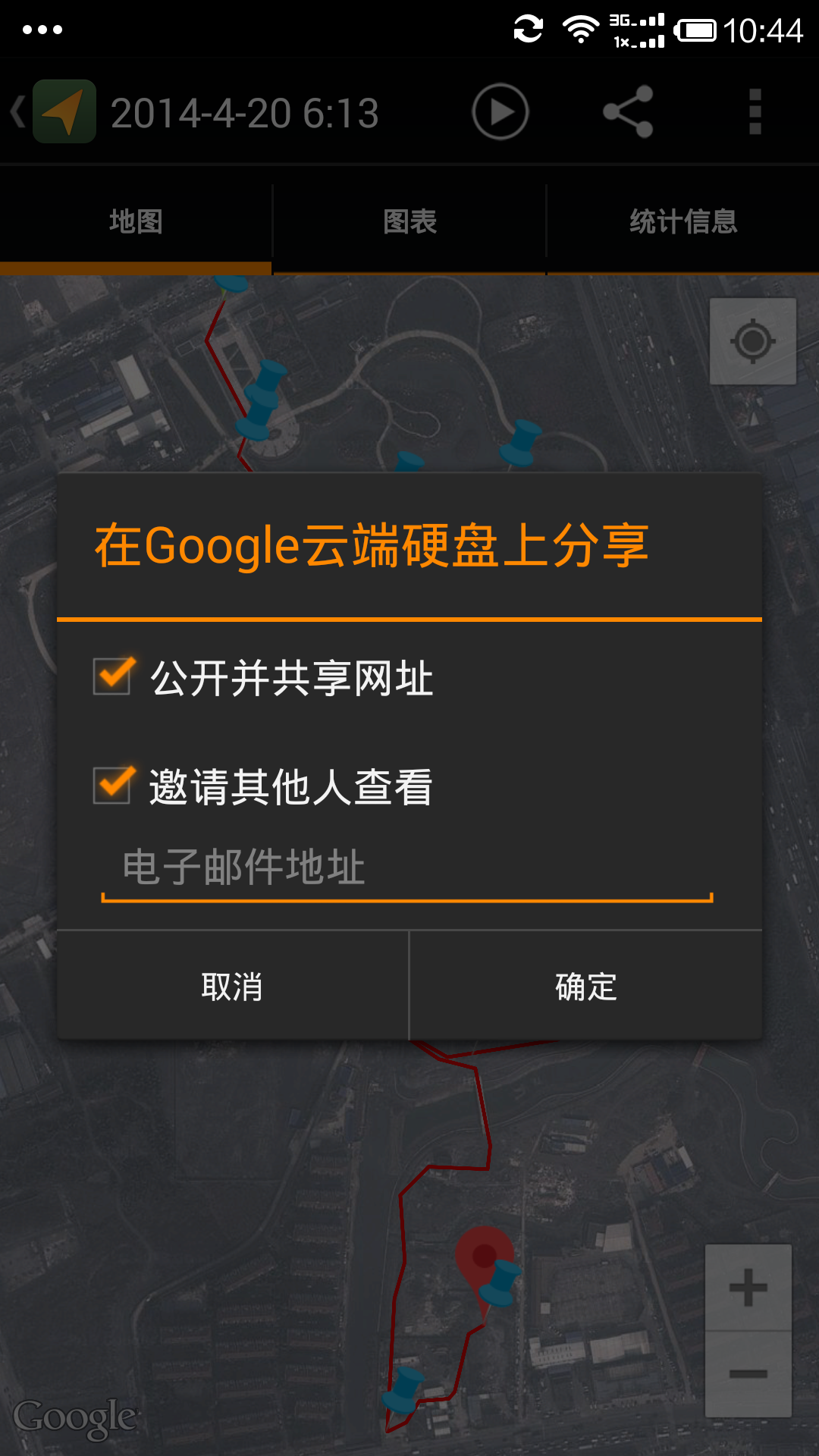
2、到邮件里点击kmz文件,或者右键点击该文件,复制链接地址,用能翻墙的浏览器打开。会引导你进入谷歌云端硬盘;
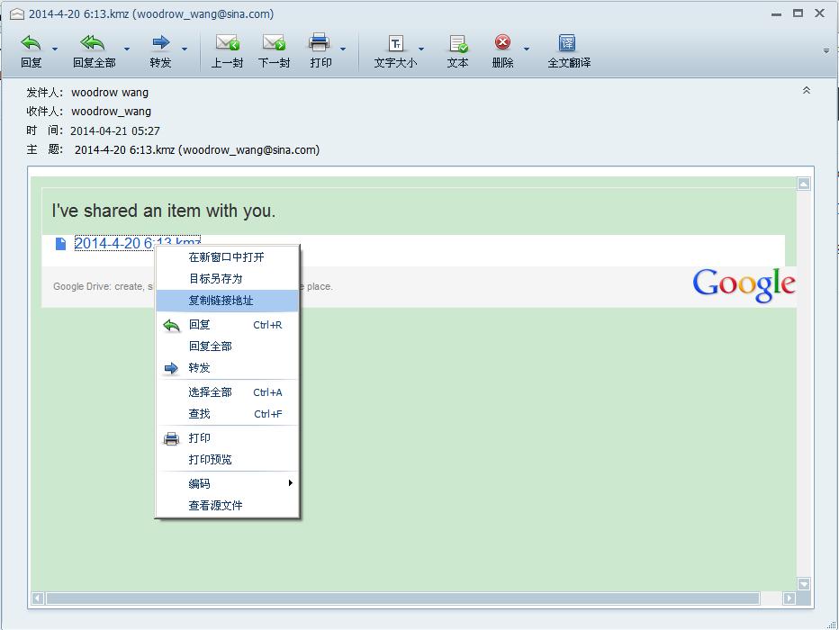
 trace1 3、把kmz文件下载下来; trace2 
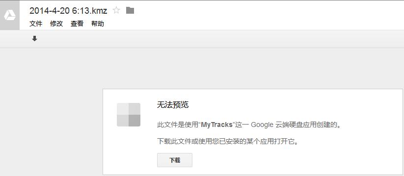
4、kmz是个压缩文件,用winrar或者其他压缩程序把kmz文件解压出来,可以看到doc.kml文件和images目录,images目录里是你拍的所有照片;

5、把所有的照片上传到您的博客的媒体库里;

6、把doc.kml文件名改为另一个好记的名字,并编辑该文件,找到所有照片文件(方法是查找”images”关键字),如果照片文件名中有空格,请把空格改为”-”,并把照片文件名前面的”images/”去掉,注意第一个查找结果:”http://earth.google.com/images”开头的不要改

7、把kml文件传到您的博客的媒体库;

8、然后你就可以再您的博客里插入短代码了(shortcode),短代码的实例如下:

trace3

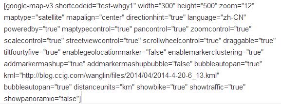
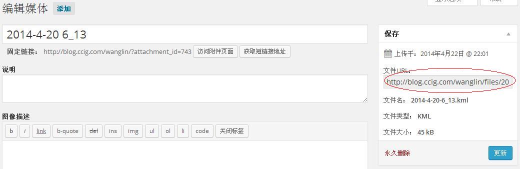
9、”kml=”后面是您刚才上传的kml的URL地址,获得该URL地址的方法是到媒体库里找到该kml文件,并进行编辑,右侧文件URL里就是您所需要,请复制/黏贴过去;

trace4

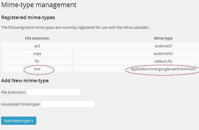
10、如果不让您上传kml后缀名的文件怎么办?请安装”PJW Mime Config”插件,安装成功以后,在设置菜单里有”Mime Types”的设置,请按下图增加kml的后缀名设置

trace5

11、如果是其他格式的GPS文件(例如GPX),可以通过下面的应用程序转换为KML格式文件。点击下载,如果想快速将GPS文件转换为KML可以访问这个网站:http://gpx2kml.com

12、短代码的说明如下:

Widget and shortcode builder settings explained

Basic Settings
 Width: The width of the map placeholder DIV in pixels or percentage  Height: The height of the map placeholder DIV in pixels only
 Zoom: Each map also contains a zoom level, which defines the resolution of the current view. Zoom levels between 0 (the lowest zoom level, in which the entire world can be seen on one map) to 19 (the highest zoom level, down to individual buildings) are possible within the normal maps view. Zoom levels vary depending on where in the world you are looking, as data in some parts of the globe is more defined than in others. Zoom levels up to 20 are possible within satellite view. Please note: when using KML/GPX/GeoRSS, the KML/GPX/GeoRSS zoom needs to be set within the KML/GPX/GeoRSS file. Zoom config option does not affect zoom of the map generated from KML/GPX/GeoRSS.  Map type: There are many types of maps available within the Google Maps. In addition to the familiar ‘painted’ road map tiles, the Google Maps API also supports other maps types. The following map types are available in the Google Maps API: ROADMAP displays the default road map view, SATELLITE displays Google Earth satellite images, HYBRID displays a mixture of normal and satellite views, TERRAIN displays a physical map based on terrain information, OSM displays OpenStreetMap imagery:Why would you use OpenStreetMap? If you collect data from Google Maps in this way, you are creating a ‘derived work’. Any such data retains the copyright conditions of the original. In practice, this means your data is subject to the licensing fees, and contractual restrictions, of these map providers. That’s exactly what Openstreetmap is trying to avoid. Please don’t be misled by considerations of software copyright, or of Terms of Use. The Google Maps API can be incorporated into open source projects, sure. But this only governs how you use the software – it doesn’t have any implications whatsoever for the data displayed by this API, which is still under copyright. please read on at http://wiki.openstreetmap.org/wiki/FAQ
 Alignment Controls alignment of the generated map on the screen: LEFT, RIGHT or CENTER. Whats actually aligned is the placeholder DIV HTML element which wraps the generated map.  Direction Hint Hint message displayed above the map, telling users if they want to get directions, they should click on map markers. ATM its in English, sorry :( Localization will come soon!
 Map Language The Google Maps API uses the browser’s preferred language setting when displaying textual information such as the names for controls, copyright notices, driving directions and labels on maps. In most cases, this is preferable; you usually do not wish to override the user’s preferred language setting. However, if you wish to change the Maps API to ignore the browser’s language setting and force it to display information in a particular language, you can by selecting on of the available languages in this setting  ‘Powered By’ Displays ‘Powered by Comprehensive Google Map Plugin’ notice under the generated map. You can choose to hide the notice, but if you want to help spread the word about the plugin, please leave this setting as ‘Enable’. Thank you ;)
Map Styles
Styled maps allow you to customize the presentation of the standard Google base maps, changing the visual display of such elements as roads, parks, and built-up areas.If you want to apply custom map styles, use the
(http://gmaps-samples-v3.googlecode.com/svn/trunk/styledmaps/wizard/index.html) to generate styles JSON. Once generated, copy the JSON (DO NOT COPY the sentence “Google Maps API v3 Styled Maps JSON”, but just the square brackets and including whats within) and paste in the text area
Map Controls
 MapType The MapType control lets the user toggle between map types (such as ROADMAP and SATELLITE). This control appears by default in the top right corner of the map  Pan The Pan control displays buttons for panning the map. This control appears by default in the top left corner of the map on non-touch devices. The Pan control also allows you to rotate 45° imagery, if available.
 Zoom The Zoom control displays a slider (for large maps) or small ‘+/-’ buttons (for small maps) to control the zoom level of the map. This control appears by default in the top left corner of the map on non-touch devices or in the bottom left corner on touch devices.  Scale The Scale control displays a map scale element. This control is not enabled by default.
 StreetView The Street View control contains a Pegman icon which can be dragged onto the map to enable Street View. This control appears by default in the top left corner of the map  ScrollWheel The Scroll Wheel control enables user to zoom in/out on mouse wheel scroll. This setting has ‘disable’ setting by default
 Map Draggable If disabled, prevents the map from being dragged. Dragging is enabled by default  Tilt 45 ° Enables the 45° imagery view. Note that the map type must be set to either SATELLITE or HYBRID for this property to work. As of February 2012, 45° aerials contain imagery of 15 U.S. and 7 international locations:
US: Charleston-Folly Beach, SC; Lee’s Summit, KS; Lexington, SC; Magna (Salt Lake City), UT; North Charleston, SC; Pine Island Center, FL; Plymouth, MN; Salinas CA; Santa Rosa, CA; Shawnee, KS; South Hill, WA; Spanish Springs, NV; Killeen, TX; Decatur, AL
Europe: Torrelavega, Spain; Pamplona, Spain; San Sebastian, Spain; Bailen, Spain; Rolle, Switzerland; Ponferrada, Spain; Wachtberg, Germany; Weinheim, Germany
SouthAmerica: Buenos Aires, Argentina
Current GPS Location
 If selected, the generated map will add end-user’s GPS current location and accuracy circle to a map upon end-user’s confirmation. The end-user can choose not to disclose his current location. The GPS marker position is automatically updated as the end-user’s position changes. Useful for users on mobile devices that want to find directions from their current location to map’s marker or vice versa. Please note, this feature will function in browsers supporting the W3C Geolocation API. This excludes Internet Explorer versions 8 and older.
Marker Clustering
 Some applications are required to display a large number of locations or markers. Naively plotting hundreds-to-thousands of markers on a map can quickly lead to a degraded user experience. Too many markers on the map cause both visual overload and sluggish interaction with the map. To overcome this poor performance, the information displayed on the map can be simplified by organizing markers into clusters
Marker GEO Mashup
 If selected, the generated map will aggregate all markers from other maps created by you in your public published posts and pages. In other words, you get a Geo marker mashup from maps across your blog/site in one map! At the moment, the mashup does not include markers from maps in widgets, POSTS and PAGES ONLY. When Geo mashup is enabled, the KML/GPX/GeoRSS and marker location form sections become hidden, in order to reduce the confusion for the user.
When selecting a marker Geo mashup, you are also given an option to select what will appear in the marker info bubble window when marker is clicked. There are two options: to display marker’s address and latitude/longitude or to display marker’s original blog post title that is linked to the post and few words from post content as an excerpt. If the original blog post already has an excerpt set, then the latter will be used for the info bubble content.
Map Markers
 Location You can enter either latitude and longitude, comma (or semi-column) seperated or a full geographical address of your destination. The latitude/longitude can be of the following format:

  • [a] N43°38 19.39, W116°14 28.86 (No apostrophe nor double quotes)
  • [b] 43°38 19.39N, 116°14 28.86W
  • [c] 43 38 19.39, -116 14 28.86
  • [d] 43.6387194445, -116.2413513485235

The generated marker will have an info bubble attached to it (activated on marker click), with marker’s address as a bubble content. If latitude/longitude was provided as a marker location, the bubble content will contain the marker’s latitude/longitude. Please note when entering geographical address – the geo addresses are validated by Google. If Google finds one or more geo addresses invalid (undetectable or unrecognizeable) you will be presented with an error dialog.

You can also select a custom icon for your marker. If none is selected, default Google marker icon is used – the red pin with black dot. Please note that markers do not support animation at the moment. Thats not all, you can also provide a custom text for your marker! The custom description will be added to info bubble in addition to the address (or lat/long) information. When entering custom marker text, no HTML tags are accepted, in other words – all HTML tags will be stripped. Although no HTML allowed, you can still insert hyper links.

Hyper links:
#Fully qualified URL starting with http(s) followed by space and a link Name#.

Please note the opening and closing hash tags, they must be present. For example:
#http://google.com Search Engine# or
#http://someblog.com Where I spent last summer#

KML/GPX/Geo RSS
 URL KML/GPX/GeoRSS is a file format used to display geographic data in an earth browser, such as Google Earth, Google Maps, and Google Maps for mobile. A KML/GPX/GeoRSS file is processed in much the same way that HTML (and XML) files are processed by web browsers. Like HTML, KML/GPX/GeoRSS has a tag-based structure with names and attributes used for specific display purposes. Thus, Google Earth and Maps act as browsers for KML/GPX/GeoRSS files. Please note, KML/GPX/GeoRSS configuration *supersedes* address and latitude/longitude settings
Marker Info Bubbles & Distance Units
 Bubble Pan Enables bubble auto-pan on marker click. By default, the info bubble will pan the map so that it is fully visible when it opens.  Distance Units Default distance unit for ‘Get Directions’ dialog. ‘Miles’ is the default value.
Custom Overlays
 Bike Paths A layer showing bike lanes and paths as overlays on a Google Map.  Traffic Info A layer showing vehicle traffic as overlay on a Google Map.
Panoramio Library
 Panoramio Panoramio (http://www.panoramio.com) is a geolocation-oriented photo sharing website. Accepted photos uploaded to the site can be accessed as a layer in Google Earth and Google Maps, with new photos being added at the end of every month. The site’s goal is to allow Google Earth users to learn more about a given area by viewing the photos that other users have taken at that place.  User ID (Opt.) If specified, the Panoramio photos displayed on the map, will be filtered based on the specifi

发表评论

电子邮件地址不会被公开。 必填项已用*标注

您可以使用这些HTML标签和属性: <a href="" title=""> <abbr title=""> <acronym title=""> <b> <blockquote cite=""> <cite> <code> <del datetime=""> <em> <i> <q cite=""> <strike> <strong>